New Features in Autodesk® Civil 3D® 2021
Autodesk® Civil 3D® 2021 contains the following new features and enhancements.
Design Efficiency Updates
- Use new and enhanced pressure network commands to create and edit path-based pressure networks.
- Add path-based pressure network pipe runs by selecting locations to define the path, or by selecting existing objects or parts in the drawing.
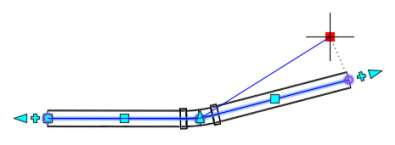
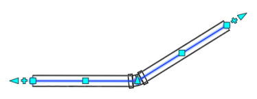
When you grip edit pipe runs to change their locations and update the pressure network path, the parts remain connected and the fittings are updated using available part sizes in the current parts list.
- Add pipe runs to an existing pressure network. A path-based pressure network can contain multiple pipe runs.
When creating a pipe run, you can optionally create a surface profile for the pipe run to follow. - Add bends automatically when creating pipe runs.
- Add branch fittings to create intersecting pipe runs, automatically using the nearest fitting size from the current parts list.
- Add and remove bends, automatically adding or removing points of intersection and fittings.
- Break or merge pipe runs.
- Use the new Pipe Run Profile Settings dialog box to control how a pipe run follows a surface or a surface profile and to add the pressure network to a new or existing profile view.
- Add path-based pressure network pipe runs by selecting locations to define the path, or by selecting existing objects or parts in the drawing.
Collaboration and Data Exchange Updates
- Use workflows between Civil 3D and InfraWorks to add bridges to your corridor designs. If the bridges are changed and republished from InfraWorks, you can reload them into your drawing.
- A roadway designer can design an alignment or a corridor in Civil 3D and then a bridge designer can bring the alignment or corridor into InfraWorks and add a bridge.
When the bridge is completed in InfraWorks, the bridge designer can publish the bridge to an IMX dataset which the road designer can bring into Civil 3D.
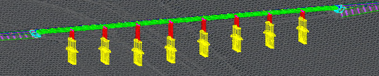
- When you open an InfraWorks dataset in Civil 3D that contains bridges, bridge objects are created in the drawing.
- The appearance of bridges in plan view is controlled using the Bridges to Civil 3D layer settings, which you can set up from the Configure InfraWorks – Civil 3D Exchange Settings dialog box.
- You can project bridges to profile view to create general arrangement sheets. When projected to profile views, the appearance of the bridges is controlled using bridge projection styles.
- If the bridge dataset is republished from InfraWorks, a message will be displayed in Civil 3D and you can reload the dataset into your drawing.
- A roadway designer can design an alignment or a corridor in Civil 3D and then a bridge designer can bring the alignment or corridor into InfraWorks and add a bridge.
For more information, see About Working With InfraWorks Bridges in Civil 3D.
- Interoperability between Civil 3D and InfraWorks for corridors has been enhanced.
- You can now create corridor component roads in InfraWorks from Civil 3D corridors.
A corridor component road represents the designed corridor in Civil 3D and is read-only in InfraWorks. - When you bring a Civil 3D corridor into InfraWorks as a corridor component road, geometry for the shapes and links is created in the InfraWorks model. You can use the Component Mapping dialog box in InfraWorks to specify how the shapes and links are mapped to materials.
- You can now create corridor component roads in InfraWorks from Civil 3D corridors.
- Options are now available in the Refine Selection Set dialog box to select InfraWorks tunnels and generic objects. InfraWorks tunnels are now brought into Civil 3D as mesh objects. Property set data is now created in Civil 3D for InfraWorks tunnels and generic objects.
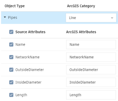
- The Publish to ArcGIS command and the Export to FGDB command now include the ability to output object properties as ArcGIS attribute information.
- Project data for use with Autodesk Collaboration for Civil 3D can be stored on the Europe data center. For more information, see Europe Data Center FAQs.
Other Updates
- The installation for Dynamo for Autodesk Civil 3D is now integrated into the installation for Civil 3D. For more information, see What Additional Applications and Utilities Are Available for Installation with Autodesk Civil 3D?
- Support for the Oregon Coordinate Reference System (OCRS) has been added.
Integration of the Autodesk Civil 3D 2020 Update Releases
The following features in the Autodesk Civil 3D 2020 Update releases have been integrated into Autodesk Civil 3D 2021. For more information, see New Features in Autodesk Civil 3D 2020.1 and New Features in Autodesk Civil 3D 2020.2.
Design Efficiency Updates from the Autodesk Civil 3D 2020 Update Releases
- Create, edit, and export rail lines. For more information, see Rail Lines.
- French and German design rules are now available for rail platform edge creation.
- The rail turnout catalog has been extended to include French turnouts based on SNCF standards.
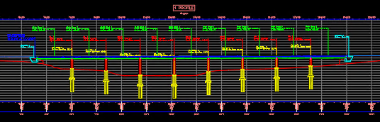
- Use new options for viewing pressure networks in profile view.
- Use enhancements to gravity network analysis including the support for multiple catchments per structure.
- Use the new drainage structure parameter mapping feature to map the parameters of Part Builder parts to parameters that are required for the Analyze Gravity Network command. For more information, see To Map Drainage Structure Parameters for Gravity Network Analysis.
Production Efficiency Updates from the Autodesk Civil 3D 2020 Update Releases
- Use enhanced reference template features to manage styles and settings. For more information, see To Set Up a Reference Template.
- The Manage Data Shortcuts command has been updated so you can specify a different data shortcut project path when the current path is still valid.
- Use a new system variable named PipeNetworkSyncMode to control the synchronization of data referenced pipe networks when you open a host drawing.
Collaboration and Data Exchange Updates from the Autodesk Civil 3D 2020 Update Releases
- Bring ArcGIS data into your Civil 3D drawings and save back,publish, and export data for use in ArcGIS. For more information, see About Working With ArcGIS Data.
- Export feature lines to LandXML files and use enhanced methods for importing feature lines from LandXML files. For more information, see Export Tab (LandXML Settings Dialog Box) and Import Tab (LandXML Settings Dialog Box).
- Collaborate on data shortcut projects in BIM 360 using the Autodesk® Collaboration for Civil 3D® entitlement. For more information, see About Autodesk Collaboration for Civil 3D.
- Access documents in your BIM 360 projects from the updated Start tab. For more information, see About the Civil 3D Start Tab.
Other Updates from the Autodesk Civil 3D 2020 Update Releases
- The behavior of some of the overlay slope options in the corridor rehab subassemblies has been updated. For more information, see Updates to the Corridor Rehab Subassemblies.
- Reports are now available on the Toolbox tab of Toolspace for reporting parcel information in a counter-clockwise direction.
- New design standards files based on the American Association of State Highway and Transportation Officials (AASHTO) 2018 design standards are included.
- Features included in the updates to Dynamo are included, including the Dynamo Player. For more information, see New Features in Dynamo for Autodesk Civil 3D 2020 Update 1 and New Features in Dynamo for Autodesk Civil 3D Update 2.
New Features in Autodesk® AutoCAD® 2021
For information about new features in AutoCAD, please see the What’s New In AutoCAD 2021 topic, the AutoCAD 2021 New Features Overview video, and the New AutoCAD Commands and System Variables Reference topic in the AutoCAD Help.